Four Counties Ring
As some of you may know, myself and three friends ventured onto the canals together in 2006, taking a lovely route in the West Midlands from New Mills to Llangollen. Well, after such an enjoyable time we decided to repeat the adventures this year, with a rather ambitious twelve day holiday taking a canal boat along the Four Counties ring.
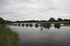
The Four Counties ring is a 110 mile tour of the Staff. & Worcester Canal, the Shropshire Union and the Trent & Mersey. The route takes you through the West Midlands, Staffordshire, Shropshire and Cheshire. Along the way you’ll encounter a variety of interesting, beautiful and fascinating locations, including the Harecastle tunnel, various industrial towns closely knitted to the history of the canals themselves and many gorgeous valleys & hills that make you really appreciate the English countryside.
The boat itself was based in the town of Shardlow in Derbyshire, which is a stone’s throw from the M1. As a result we immediately had some extra distance to cover to even reach the Four Counties tour – an extra 38 miles each way to get from Shardlow to Great Haywood Junction.
The incredibly handy Canal Planner suggested a distance of 186 miles, taking nearly eleven days at 9 hours’ cruising time per day. We had twelve, although much of the first day would be spent travelling up & getting shopping in and the last day would be for cleaning and leaving the boat by 4pm. CanalPlan also prepared us for the amount of work ahead – 136 locks.
After a smooth journey up and an easy start, we hoped for plain sailing. Unfortunately the heavens opened (in a substantial way) and ensured an almost continual deluge for much of the holiday. Still, people don’t holiday in Britain because they expect lovely weather… we endured the rain but suffered delays several times because of closed locks and overflowing canals.
Since returning, many people have jokingly suggested that being on a canal boat makes life easy during flooding; that we should’ve suffered few problems. Quite the contrary: because canals are often used as part of flood control their use is carefully controlled during heavy rain. Towards the end of the holiday in particular, we were held up outside Shardlow as the Environment Agency had closed two locks either side of the town. The lower lock prevented too much canal water entering the River Trent (and thus contributing to the river’s already excessive volume); the upper lock closed simply to prevent Shardlow itself from being flooded by the water trapped between the two locks. As you will read below, we were fortunately granted access through the upper lock to reach our destination Wharf, but the entire process was very carefully monitored by EA staff downstreams who watched the levels very precisely.
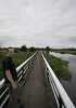
Furthermore, because many bridges are designed to accommodate a particular size of craft underneath them there is often very little clearance between the boat and the bridge. Although in our case we had very little more than a mop on the roof, boats with higher fixtures simply did not have enough headroom between the underside of the bridge and the flooded canal.
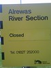
Finally, with the River Trent carrying so much water from the hills it became utterly dangerous to cross at the point the Trent & Mersey canal traverses the Trent at Alrewas. British Waterways, the organisation charged with the maintenance of the canals, closed the locks either side of the Alrewas crossing for some time (we met fellow boaters who’d been waiting for two days). One of our planning mistakes was to fail to realise that the T&M canal crossed the Trent, although it would have made little difference to the outcome; the crossing is a necessary and unavoidable part of the route to the Four Counties Ring.
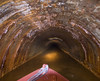
If you are planning a similar journey, I would certainly recommend taking a look at CanalPlan. It really is an invaluable bit of route planning and contains much useful information. The website itself can take some getting used to (it has a fairly steep learning curve and the interface is a little tricky at times) but the results are very useful and detailed indeed. Once you have prepared a route, study it carefully and make sure you know what to expect in terms of hazards (eg. river crossings) and other points of information. CanalPlan will, for instance, remind you that the Harecastle Tunnel on the Trent & Mersey has restricted opening times (it is a single tunnel, and the direction of travel is switched at regular intervals).
I have been asked whether I would recommend hiring boats from bases where a river crossing is necessary (Canal Time, for instance, has a base in Shardlow so a crossing of the Trent at Alrewas is pretty inevitable). Personally I felt we were particularly unlucky with the weather, and in most cases the crossing would not be a problem. On that basis, hiring a boat in those parts would be fine I’m sure. If you happen to take a boat during a particularly nasty stretch of weather perhaps it would be worth considering a different location: most hire companies have multiple bases to accommodate one way journeys. If anybody has any further thoughts on this please contact me and I’ll add comments accordingly.
As for our journey, you can read the log and see photos below. Chris also has an account of the journey at his blog for a second point-of-view. To sum up, the Four Counties Ring is a beautiful tour of the English countryside, includes some wonderful natural and industrial sights, and passes through some important historical parts of the canal system. The Ring is largely a pleasure to navigate, but the route as a whole does comprise some tricky sets of locks: Heartbreak Hill near Sandbach on the T&M has some 26 locks in quick succession (enough to justify staying on the path through most of it) which can take an entire day to get through. If you follow our route, the double-width locks on the Trent and Mersey towards Shardlow can also exercise the body: each lock gate weighs upwards of two tonnes. Finally, the Harecastle tunnel can take 45 minutes to pass through – at times neither end can be seen (particularly if they shut the doors…); not for the claustrophobic!
Cruising Log
Saturday 16 June 2007
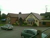
Set off 2.30pm from Dobson’s marina in Shardlow on the Trent & Mersey canal. Hail and thunder, with the occassional sunny spell greet us on our first day. Stopped at the Bubble Inn pub, near Stenson Lock – it’s a lovely pub with nice food and easy access to the canal.
Sunday 17 June 2007
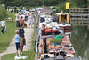
Set off at 9am. Weather is still a bit iffy but not as bad. After a few hours of oncoming boaters warning us that ‘the river is closed’ we realise that the river is not just an adjunct to our path – we actually have to cross it. Get to Alrewas to discover that, as indicated, the river is closed and nobody can get through. It’s then that we realise quite how bad the weather is up in the hills.
Unfortunately, being a Sunday there’s nobody manning the British Waterways phonelines or the regional office, and the BW website completely fails (probably for the same reason) to show that the canal is even shut.
After talking to a few other boaters in the queue we decide to take a walk up to the village.
In Alrewas, from Bridge 46 head towards the town, follow Post Office Road to the far end and turn left. There is a Co-op (late opening) allong the road about 200yds.
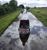
Luckily about 9.30pm we manage to get through the lock and put the engine revs up for a mighty crossing of a flooded (and very strong) Trent. Two locks up we find a mooring point and settle down for the night.
 Â
  Â
  Â
  Â
Hosted by Flickr. Images © 2007 Sven Latham
Monday 18 June 2007
Finally the weather turns in our favour: only a few showers through the day and some reasonable stretches of sunshine. Stopped at the Ash Tree pub (very accessible) just before Rugeley for a lovely 2-for-1 meal.
Manage to make it to the Stafford & Worcestershire canal, and stop at bridge 94 for the evening.
Tuesday 19 June 2007
Nice early(ish) start at 8am. We find a little restaurant/bar at Hatherton Junction called Misty’s. Straightforward sandwiches; nothing special but a welcoming couple.
Get all the way down to the most Southerly point at Autherley Junction and then back up to Bridge 21 on the Shropshire Union before we settle down for the night.
Wednesday 20 June 2007
Set off at 8.30; finish at 8.30. Stopped at Bridge 83 – covered much of the Shropshire Union today, passing Norbury Junction and Market Drayton on the way.
Thursday 21 June 2007
Set off at 8.30. Pass Hurleston Junction where we joined the Llangollen canal last year. Through the town of Middlewich, where we got stuck in traffic last year! (fortunately a smoother, less congested cruising this time). Two days after the most Southerly point on the route, we are now at the most Northerly: Middlewich. Passed some kind of salt mountain just south of Middlewich.
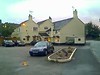
Stopped at Wheelock (which we remembered fondly from last year). Quick drink at the Cheshire Cheese – unfortunately they don’t serve food, so off to the ‘Dragon City’ Chinese place around the corner.
 Â
  Â
  Â
Hosted by Flickr. Images © 2007 Sven Latham
Friday 22 June 2007
Bit of a lie-in this morning, finally casting off at 10.30 – maybe because we know what lies ahead: Heartbreak Hill. This set of 26 locks would’ve been tiresome at the best of times (they take roughly an entire day to get up), but we have the added misfortune of rain the whole way up, sometimes quite torrential too.
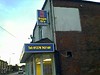
Stopped at Café Lock 57 for lunch for some nice food, but after a rotten day we couldn’t have asked for a nicer meal in the evening at the Lawton Arms in Congleton (nr Lock 47). We were unanimous in our delight at this place – some seriously nice food and very friendly staff too. It’s a bit of a trek but highly recommended.
Saturday 23 June 2007
Cast off at 8am. Finished the last few locks of Heartbreak Hill then a cruise through the Harecastle Tunnel.
After the tunnel, we venture through Stoke on Trent. I’ve read and heard that this is not a pleasant place to stop at night (I’m sure it’s otherwise lovely…) so we trek on and aim to get out of the town before sundown
Stopped below the last lock in Stone – which can be quite a busy mooring area it seems. Stone has a Morrison’s and Somerfield, as well as some nice looking canalside pubs – although we spent the night inside.
Sunday 24 June 2007
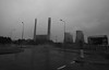
9am start for a steady cruise through to Rugeley, and the return leg home. Bridge 66 has a nice mooring point, and just over the bridge you’ll find a Morrison’s and a Wilkinson store. On the other side, if you head towards Rugeley B Coal Power Plant, you’ll find a breakfast/burger van at the entrance roundabout. If fry-ups are your thing (I’m a bit partial to some) I thoroughly recommend stopping by “Leeanne’s Munch Box” for a delicious breakfast.
Yet again the weather is awful, but hey – Wimbledon has begun, so….
 Â
  Â
  Â
Hosted by Flickr. Images © 2007 Sven Latham
Monday 25 June 2007
Rain. Rain. Rain.
Managed to get through Alrewas just before they shut it again. The Trent is up high again and rapidly rising. Thankfully we’re heading downstream so less effort and a quicker journey through, although once again the anchor is prepared ‘just in case’!
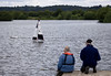
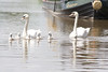
Stop for the night nr Branston village by the Water Park. Some nice lakeside views and various natural delights there. We wander into Branston village and find a Shop + Post Office in town, as well as a Fish & Chip shop.
Tuesday 26 June 2007
A lazy day today since we’re ahead of schedule.
Stopped by the old Tollhouse (site of the former Derby canal junction) nr Bridge 14. Swarkestone village has a nice pub called the Crewe and Harpur – bit of a gastro but welcome nonetheless. If you moor at the old Tollhouse follow the lane under the railway bridge, turn right at the end and follow the road for about a quarter of a mile.
 Â
  Â
  Â
 
Hosted by Flickr. Images © 2007 Sven Latham
Wednesday 27 June 2007
Set off at 9.30 with a freshly painted boat to return to Dobson’s. Finally, some nice sunshine – Sod’s Law it’s our last day.
Got stuck at Shardlow Lock 2 because Lock 1 (Trent access lock) is shut and there is a danger of water flooding between the two locks.
Thankfully an Environment Agency chap comes along to open the lock for four boats (the lock is a double), while carefully monitoring the downstream water levels.
With the boatyard in tantalising sight, we manage to secure a place and get through the lock: the fourth boat! As if by magic the heavens open again, and we’re once again treated to a deluge just as we return the boat.
90 hours of cruising, covering some 186 miles. A lovely time (despite the rain).
Sven Latham, 13 August 2007