Watching the Watchers

Last night, Google released an update to its Street View system to include new locations across the UK, Netherlands and other European countries.

My home city, Portsmouth, is not on there yet but Southampton is so, clicking through my old university stomping ground I came across this little treat:
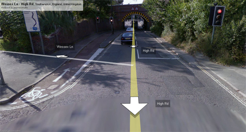
shot1

First shot: The Google Car may or may not have gone through the first red lights. Who knows… the lights ahead are already on amber.
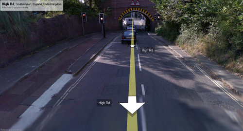
shot2

Second shot: Lights are still on amber. Technically you should be preparing to stop 😉
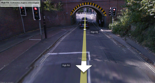
shot3

Third shot: They’re red. Is the driver still going? Watch the two cars in front – a white one and a dark blue one. Also, note the two schoolkids walking under the tunnel.
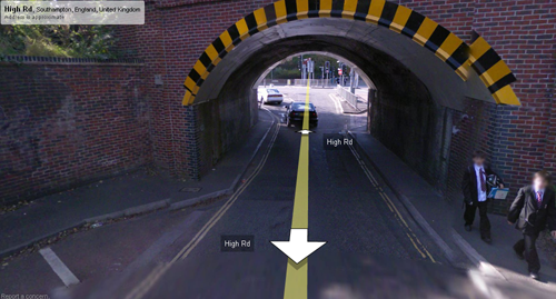
shot4

Fourth shot: The two cars ahead are further away – either they sped up or the driver is slowing down… maybe he stopped after all? Note the two kids are closer too, so it’s a continuous set of frames
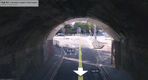
shot5

Fifth shot: The two cars are well away now, already around the left-hand bend. There’s no reason to believe from this particular shot that it’s a few seconds after the last – the driver might’ve waited for a green and gone a bit later, right? Well, take a look for yourself at the car behind the driver, and the two schoolkids will still be there. In the distance, cars are starting to come towards our fearless driver…
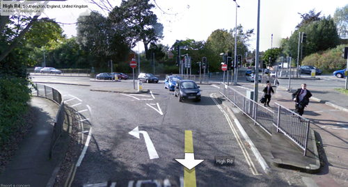
shot6

Final shot: there are more schoolkids running under the bridge, and the oncoming cars are now having to wait for our Google Driver to get out of the way!

Conclusion: well, none really. This is a pointless, but mildly satisfying discovery. Enjoy.
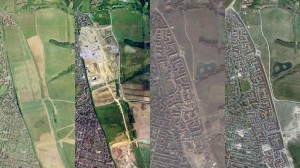
Google Earth 5.0

Google’s 3D world viewer, Google Earth has been updated to version 5.

The headline feature is the ability to view historic satellite photos, as in this picture of Cherque Farm housing estate, near Lee on Solent, Hampshire, UK.


Housing estate nr. Lee on Solent, Hampshire UK

In the series of photos, ranging from 1999 (left) to 2007 you can clearly see the construction of the estate over time.

Gap-aware locators

One notable thing about most location software is that it is usually fairly crude.

Most programmers take the easy route and simply work out the distance between two points via a bit of trig. Some smarter programmers are aware of the Earth’s curviture and bear this in mind.

Usually – this is as far as it goes. The classic “find my nearest” search is great for most places but is a rough ‘as the crow flies’ measurement.

Living for a while on the Isle of Wight, I came to appreciate that while this normally works OK, on an island it’s a profoundly dumb system.

If, for instance, you live in Ryde (north coast of the Isle of Wight) most systems will recommend a shop in Portsmouth or Gosport before the more sensible option in Newport or elsewhere on the island. A bit daft really, considering to get to the ‘closer’ shop might be one or two ferries at the least.

Today, I noticed that the Maplin website actually excludes shops which might fall in the radius of consideration, but are much trickier to get to.

Searching for an item from my Fareham (mainland) address gives plenty of options, but the Newport store (10.7mi as the crow flies) is not included.

Similarly, searching from an island postcode gives the Newport store only as an option.

I suspect that – instead of running calculations by travel time – somebody has manually identified island postcodes, mainland postcodes and separated them by zone so only those postcodes in the same ‘zone’ appear in the search… that’s certainly my first instinct (I’d love to think they’re doing a full journey check, but I somehow doubt it 😉 )

While it’s not perfect (maybe the Newport address could be grouped separately, in case I happened to be going over to the island anyway), it’s a step further than most location-based searches out there.

A303 Diversion

Apparantly the big news in the Westcountry is that the A303 is to be closed some time early next year, with a 40 mile diversion. The BBC has more details and the Highways Agency press release is also available.

I wondered why neither the HA nor any of the press articles I’d seen bothered publishing a map. While they’re happy to describe an elaborate route in text, it took me less than five minutes to knock this up.

The visual view is – I think – much more explanatory than any text, and it adds instant impact to the article.

VAT Dropped Today

Good morning! It’s just gone 7am and those programmers out there involved in EPOS and e-commerce systems are either sitting smug or are running around trying to get the computers updated before the shops open.

Today’s the day standard rate of VAT (sales tax) drops from 17.5% to 15%, in a move by the Chancellor to encourage spending. Whether it works or not remains to be seen, I’ve heard that many shops are simply keeping prices as-is, and pocketing the slight difference in markup from each sale. Some high-street shops have bizarre “offers” highlighting the VAT drop as the reason but (in one case) “offer ends 3 December”.

In view of all of this number-crunching fun, I’ve produced a handy VAT Check Sheet for download, which allows you to see the VAT difference, new totals and how much shops should be dropping prices. I think the numbers are right but if anybody has any corrections, thoughts or comments I’ll be happy to update.

The Obligatory “I’m Still Alive” Post

It’s been a fair while since my last post. Various reasons come to mind but for me the biggest focus of the last six weeks has been my company, which has taken a far greater chunk of my attention in recent times.

While plenty of things have happened recently, I’m going to try focusing on my business as the basis for a series of new articles on this blog. I’m hoping to talk more about my experiences, ups and downs with the hope that this kind of writing will be useful to others.

The usual common-sense disclaimer applies: anything I write is personal, (usually) unqualified and should not be viewed as definitive. Simply take them as they are: anecdotal.

I’ll be writing the first article real soon now, and you are actively encouraged to reply and give your own thoughts.

Going Solo – Review

Last Friday I spent the day in Old Broadcasting House, Leeds with a group of like-minded people interested in starting, or already on their freelance journey.

The event, organised by Stephanie Booth was originally intended to be a larger conference but due to disappointing numbers it was cancelled. The attendees were instead invited to a smaller, less formal gathering called SoloCamp.

The twenty-or-so of us who attended spent the day talking about a variety of issues: Finance, Confidence, Growth and Clients. The full overview of the day can be found on the SoloCamp wiki.

This was my first “BarCamp” style event, and I took the opportunity to get some presentational confidence by moderating the Growth session. I had a bit of a stumble with the session as my ad-hoc material quickly ran out, but thankfully the session turned into a rather interesting discussion about Hype Cycles towards the end (thanks to Dennis!).

All in all, a very interesting and educational experience. It gave me renewed enthusiasm about getting my company up and properly running. It also had me thinking about charging policies, marketing and finance, all of which are very important to a vulnerable technology start-up. More generally, it has been a great pleasure meeting a variety of individuals, from various backgrounds who I hope to keep in touch with.

Google Gears + iamnear.net Demo

Finally, I’m back into doing something that I love – fiddling with new ideas.

Today, Google released Google Gears 0.4 with geolocation. For those of you not yet aware of Google Gears, it’s an attempt by the big G to enhance the client-side with a variety of rich add-ons, such as local databases, offline services and smoother integration with the host OS.

Gears is also available for Windows Mobile devices and, with the addition of geolocation, adds some exciting spice to the mobile platform.

Previously I’ve made aborted attempts to use a combination of Navizon (a mobile tracking service), Fire Eagle (Yahoo!’s location “platform”) and iamnear.net (Tom Taylor‘s very handy directory of POIs). It works to a point, but is a hopelessly elongated way of serving geo-aware content from a web browser.

With Gears 0.4 it’s now possible for the browser to interrogate directly the user’s location, through a combination of cell IDs and GPS (where available). The natural conclusion is to slap this tool onto the front of something like iamnear.net, et voila, you have a location-aware website puling information directly from the client.

Without further ado, check out my painfully basic demo – you’ll need Windows Mobile 5/6 and Google Gears (if it is not detected, it’ll prompt you to install).

As a bonus, the site will also work on your desktop, but I’m presuming that’d only be available with a GPS dongle of some kind?

I’d love to spice it up a bit – actually without presuming too much I’m fairly sure this is a natural upgrade to iamnear.net and other sites… if you have any thoughts feel free to post below 😉